
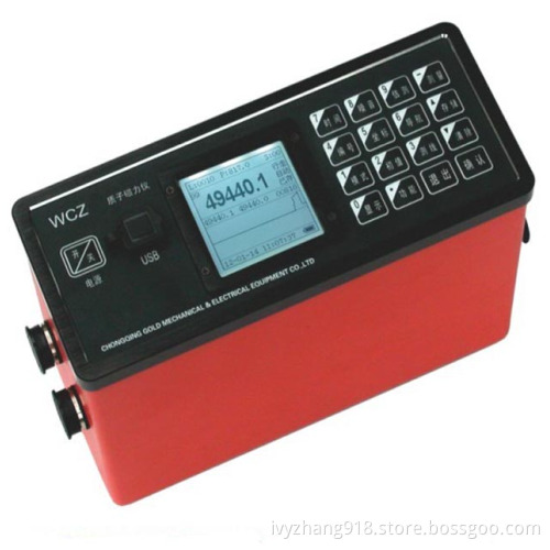
Proton Magnetometer for Mineral Prospecting, Such as Iron Ore, Lead-Zinc Mine, Cooper Mine
- Payment Type:
- L/C, T/T
Quantity:
Your message must be between 20 to 2000 characters
Contact NowBasic Info
Basic Info
| Place of Origin: | China |
|---|---|
| Payment Type: | L/C, T/T |
Product Description
Product Description
Product Description
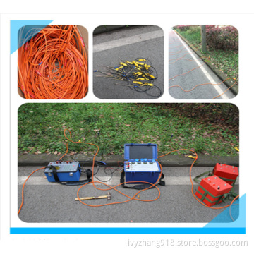
I. Application
Mineral prospecting, such as iron ore, lead-zinc mine, cooper mine.
Cooperative mine prospecting, study the ore body's burial depth, dipping and continuity, study the ore body's shape, size, estimate mineral bed's scale.
Prospecting for gas or oil, research geologic structure relevant to gas or oil
Geologic survey, geologic mapping
Ground diurnal variation for aero-magnetic and marine magnetic survey
Faults orientation.
Archaeology
Hydrology
Engineering prospecting, e. G, pipeline finding.
Earthquake monitoring, volcano monitoring, and other environmental and disaster.
Ferromagnetic objects finding.
II. Features
Geomagnetic field and normal gradient of geomagnetic field (horizontal gradient component of geomagnetic field or vertical gradient component of geomagnetic field, need special sonde and support).
Applicable in field survey or base station measurement.
It has internal clock, store the data and the time together, measure and store at a fixed time.
Large display, show magnetic curve automatically, easily operation
Backlight LCD screen, can be used at night.
Personal keyboard, can be used by both hands.
Automatically or manually tuned.
Portable, all system use gallus, one person can accomplish all task.
RS-232C interface
Geologic software for mapping isoclines and section.
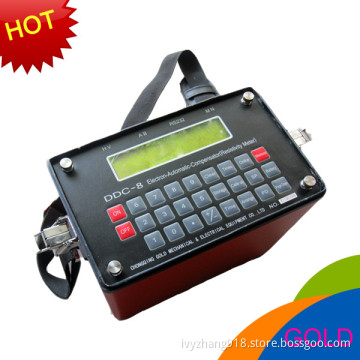
III. Technical specifications
Measurement range: 20000nT~100000nT
Measurement precision: 1nT
Resolving power: 0.1T
Allowed gradient: 5000Nt /m
Data stored: 100, 000, out-power protection
LCD screen: 240x128
Keyboard: 22 keys
Interface: RS-232C standard serial port
Power: Outside rechargeable batteries, 12V/2.3Ah, also power outside
Bulk of mainframe: 230mmx155mmx65mm
Weight of mainframe: 2.5kg(include batteries)
Bulk of sonde: 75mmx155mm
Weight of sonde: 0.8kg
Mineral prospecting, such as iron ore, lead-zinc mine, cooper mine.
Cooperative mine prospecting, study the ore body's burial depth, dipping and continuity, study the ore body's shape, size, estimate mineral bed's scale.
Prospecting for gas or oil, research geologic structure relevant to gas or oil
Geologic survey, geologic mapping
Ground diurnal variation for aero-magnetic and marine magnetic survey
Faults orientation.
Archaeology
Hydrology
Engineering prospecting, e. G, pipeline finding.
Earthquake monitoring, volcano monitoring, and other environmental and disaster.
Ferromagnetic objects finding.
II. Features
Geomagnetic field and normal gradient of geomagnetic field (horizontal gradient component of geomagnetic field or vertical gradient component of geomagnetic field, need special sonde and support).
Applicable in field survey or base station measurement.
It has internal clock, store the data and the time together, measure and store at a fixed time.
Large display, show magnetic curve automatically, easily operation
Backlight LCD screen, can be used at night.
Personal keyboard, can be used by both hands.
Automatically or manually tuned.
Portable, all system use gallus, one person can accomplish all task.
RS-232C interface
Geologic software for mapping isoclines and section.
III. Technical specifications
Measurement range: 20000nT~100000nT
Measurement precision: 1nT
Resolving power: 0.1T
Allowed gradient: 5000Nt /m
Data stored: 100, 000, out-power protection
LCD screen: 240x128
Keyboard: 22 keys
Interface: RS-232C standard serial port
Power: Outside rechargeable batteries, 12V/2.3Ah, also power outside
Bulk of mainframe: 230mmx155mmx65mm
Weight of mainframe: 2.5kg(include batteries)
Bulk of sonde: 75mmx155mm
Weight of sonde: 0.8kg
Related Keywords
Related Keywords
You May Also Like
You May Also Like
-
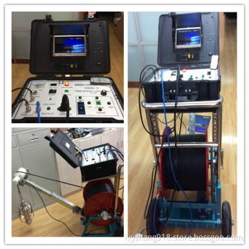
360 Degree Rotary Borehole Inspection Camera Underwater Camera
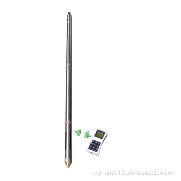
Remote Control Digital Incinometer, Borehole Inclinometer, Inclinaton Tester
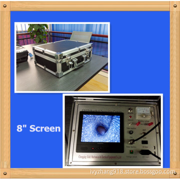
Underwater Water Well Inspection Camera and Borehole Video Camera
Ves Spontaneous Potential Water Exploration, Underground Water Detector,
Good Feedback Geological Prospecting Ground Water Detection, Water Finder
Related Products-
Ves Spontaneous Potential Water Exploration, Underground Water Detector,
-
Underwater Water Well Inspection Camera and Borehole Video Camera
-
Remote Control Digital Incinometer, Borehole Inclinometer, Inclinaton Tester
-
360 Degree Rotary Borehole Inspection Camera Underwater Camera
-
Digital DC Earth Resistivity Meter Geophysical Exploration
Product Categories