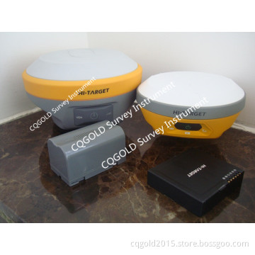

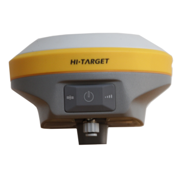
Hi-Target V90 GNSS RTK SYSTEM
- Payment Type:
- T/T, L/C, Western Union
- Incoterm:
- FOB
- Min. Order:
- 1 Set/Sets
- Min. Order:
- 1 Set/Sets
- Delivery Time:
- 15 Days
- Transportation:
- Ocean, Land, Air
Your message must be between 20 to 2000 characters
Contact Now| Place of Origin: | China |
|---|---|
| Productivity: | 100 pcs |
| Supply Ability: | 1000 pcs per month |
| Payment Type: | T/T,L/C,Western Union |
| Incoterm: | FOB |
| Certificate: | ISO9001 |
| Transportation: | Ocean,Land,Air |
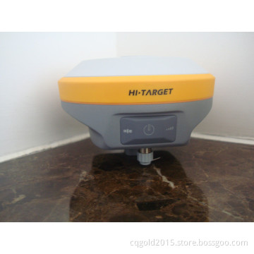
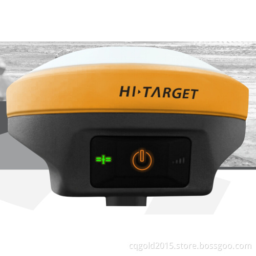
HI TARGET V90 PLUS RTK GPS GNSS RTK
With a hi-tech, fully integrated design, the conveniently sized V90Plus is one of the most flexible choices for any measuring task. Built-in Linux3.2.0 operating system, pre-loaded multiple smart applications such as tilt surveying, electronic bubble calibration, NFC and voice DIY, V90Plus GNSS system provides surveyor industry-leading GNSS solutions.
Small and lightweight
Multi-constellation Tracking
· 220 tracking channels
· Supports GPS, GLONASS, GALILEO, BDS, SBAS
· NGS approved full-band GNSS antenna
· The transceiver UHF radio enables switchable working modes between base and rover.
· Three types of internal UHF radio provide different frequencies based on users requirements. The Pacific Crest TrimTalk© internal UHF radio is compatible with other radios.
· Supports GPRS, GSM and WCDMA
· Supports WIFI
Powered by high-capacity (5000mAh) Li-ion battery to ensure full day operation
IP67 dustproof and waterproof
Able to survive a 3-meter natural fall onto concrete
Satellite Signals Tracked Simultaneously
Static and Fast Static GNSS Surveying
Smart Application
Offers tilt survey with a maximum tilt angle of 30 degrees.
Supports electronic bubble calibration
The internal NFC module makes Bluetooth communication quick and easy.
Intelligent voice assistance guides field operations. Voice can be DIY.
Standard Rinex data and HI-TARGET raw data recorded simultaneously.
Optional Transceiver UHF Radio
Multi-network Connection
Powerful Battery
Rugged Design
220 Channels
GPS---.. Simultaneous L1C/A, L2C, L2E, L5
GLONASS-----..Simultaneous L1C/A, L1P, L2C/A (GLONASS M only), L2P
SBAS--------. Simultaneous L1 C/A, L5
Galileo------... Simultaneous L1 BOC, E5A, E5B, E5AltBOC
BDS------..--.-----------. B1, B2
QZSS--------.. L1 C/A, L1 SAIF, L2C, L5
POSITIONING PERFORMANCE
Horizontal--------2.5mm+0.5ppm RMS
Vertical----------. 5mm+0.5ppm RMS
Post Processing Kinematic (PPK / Stop & Go) GNSS Surveying
Horizontal---------.. 1cm+1ppm RMS
Vertical---------- 2.5cm+1ppm RMS
Initialization time---.Typically 10 minutes for base while 5 minutes for rover
Initialization reliability--Typically > 99.9%
Real Time Kinematic (RTK) Surveying
Single Baseline
Horizontal---------.. 8mm+1ppm RMS
Vertical----------. 15mm+1ppm RMS
Network RTK
Horizontal---------.. 8mm+0.5ppm RMS
Vertical----------.. 15mm+0.5ppm RMS
Initialization time--..-Typically < 8seconds
Initialization reliability--.Typically > 99.9%
Code Differential GNSS Positioning
Horizontal---------. 25cm+1ppm RMS
Vertical----------- 50cm+1ppm RMS
SBAS --- 0.50m Horizontal, 0.85m Vertical
HARDWARE
Physical
Dimensions (W x H)--.153mm x 83mm (6.02inch x 3.27inch)
Weight---950g (2.09lb) without internal battery
Operating temperature---. -40℃to +65℃ (-40℉ to +149℉)
Storage temperature----. -40℃ to +75℃(-40℉ to +167℉)
Humidity---------. 100%, considering
Water/dustproof------.. IP67 dustproof, protected from temporary immersion to depth of 1m (3.28ft).
Shock and vibration-----Designed to survive a 3m(9.84ft) natural fall onto concrete.
Electrical
Power 6V to 28V DC external power input
Power consumption ≤3.5W
Automatic switching between internal power and external power
Rechargeable, removable 7.4V, 5000mAh Lithium-ion battery in internal battery compartment
Internal Battery Life
Static 12hours
RTK rover (UHF/GPRS/3G) 8-10 hours
RTK base 8 hours
I/O Interface
1 xBluetooth, NFC
1 x standard USB2.0 port
1 x TNC antenna connector
1 x RS232 serial port
1 x DC power input (5-pin)
Tilt Survey System
Electronic Bubble
COMMUNICATION
Network Communication
Fully integrated, fully sealed internal WCDMA, compatible with GPRS, GSM
Wifi frequency is 2.4G, supports 802.11b/g/n protocol
Network RTK (via CORS) range20-50km
HI-TARGET Internal UHF Radio(Standard)
Frequency- 450~470MHz with 116 channels
Transmitting power-0.5W, 1W, 2W adjustable
Transmitting speed---.9.6Kbps, 19.2Kbps
Working range----.3~5km typical, 8~10kmoptimal
Pacific Crest XDL Micro Internal UHF Radio
Frequency-----------.403~473MHz
Transmitting power------ 0.5W, 2W adjustable
Transmitting speed-----.. Up to 19.2Kbps
Support most of radio communication protocol
Working range--------- 3~5km typical, 8~10km optimal
HI-TARGET External UHF Radio (Standard)
Frequency---- 460MHz with 116 channels
Transmitting power--. 5W, 10W, 20W, 30W adjustable
Transmitting speed----- Up to 19.2Kbps
Working range-------. 8~10km typical, 15~20km optimal
Pacific Crest ADL Vantage Pro External UHF Radio
Frequency-. 390~430MHz or 430~470MHz
Transmitting power-.. 4W to 35W adjustable
Transmitting speed-----.. Up to 19.2Kbps
Support most of radio communication protocol
Working range-. 8~10km typical, 15~20km optimal
SYSTEM CONFIGURATION
System
Data storage-------16GB Internal storage (Support up to 32GB external SD card)
Record GNS and RINEX format simultaneously
Data Formats
1Hz positioning output, up to 20Hz
CMR: CMR, CMR+, sCMRx input and output
RTCM: RTCM 2.1, 2.3, 3.0, 3.1, 3.2 input and output
Navigation outputs ASCII: NMEA-0183 GSV, AVR, RMC, HDT, VGK, VHD, ROT, GGK, GGA, GSA, ZDA, VTG, GST, PJT, PJK, BPQ, GLL, GRS, GBS
Navigation outputs binary: GSOF
Related Keywords