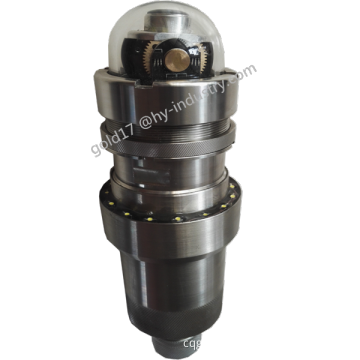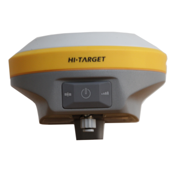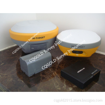


Dual Frequency V30 GNSS GPS RTK
- Payment Type:
- T/T, Western Union
- Incoterm:
- FOB
- Min. Order:
- 1 Set/Sets
- Min. Order:
- 1 Set/Sets
- Delivery Time:
- 15 Days
- Transportation:
- Ocean, Land, Air
Your message must be between 20 to 2000 characters
Contact Now| Place of Origin: | China |
|---|---|
| Productivity: | 100 pcs |
| Supply Ability: | 100 pcs per month |
| Payment Type: | T/T,Western Union |
| Incoterm: | FOB |
| Certificate: | ISO9001 |
| Transportation: | Ocean,Land,Air |
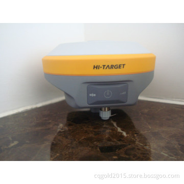
Cheap price Hi Target V30 GNSS RTK receiver with 220 Channels, Android controller RTK GPS
Multi-satellite & multi-system tracking
The V30 GNSS RTK system is designed to meet high quality standards at an affordable price. It is outstanding in its class, with a rugged design and user-friendly functions.
|
Performance Specification of V30 |
||
|
Measurements |
220 channels |
|
|
Advanced Pacific Crest Maxwell 6 Custom Survey GNSS Technology |
||
|
High precision multiple collector for GNSS pesudo range |
||
|
Very low noise GNSS carrier phase measurements with<1mm precision in a 1 Hz bandwidth |
||
|
Proven Pacific Crest low elevation tracking technology |
||
|
Satellite Signals Tracked |
GPS: L1C/A, L2C, L2E, L5 |
|
|
GLONASS: L1C/A, L1P, L2C/A (GLONASS M only), L2P |
||
|
SBAS: WAAS, MSAS, ENGOS |
||
|
Galileo: reserve for upgrading |
||
|
BDS: B1, B2 |
||
|
Positioning |
Static and Fast Static |
Horizontal: ± (2.5mm+1x10⁻⁶ D) |
|
Vertical: ± (2.5mm+1x10⁻⁶ D) |
||
|
Real time Kinematic(RTK)surveying |
Horizontal: ± (10mm+1x10⁻⁶ D) |
|
|
Vertical: ± (20mm+1x10⁻⁶ D) |
||
|
Initialization time typically < 10seconds |
||
|
Initialization reliability typically > 99.9% |
||
|
Hardware |
Physical |
Dimensions(W × H):19.50cm×10.4cm |
|
Weight:1.3kgs (2.76lbs) with internal battery |
||
|
Operating:-45°C to +65°C (-49°F to +149°F) |
||
|
Storage temperature: -55°C to +85°C (-67°F to +185°F) |
||
|
Humidity:100%, considering |
||
|
Water/dust proof: IP67 dust proof, protected from |
||
|
temporary immersion to depth of 2m |
||
|
Shock and Vibration.Designed to survive |
||
|
a 3m(9.84ft) nature fall onto concrete. |
||
|
Electrical |
Power 6V to 36V DC external power input |
|
|
Power consumption: 2.5W |
||
|
Battery:High-capacity lithium battery 5000mAh/block ( 2 blocks), |
||
|
single battery can work for 12 hours on GPS rover station |
||
|
I/O interface |
1×Bluetooth |
|
|
1×standard USB2.0 port |
||
|
2×RS232 serial port |
||
|
2×DC power input(8-pin & 5-pin) |
||
|
1×Micro SD card port for GSM or CDMA |
||
|
Communication |
3G Communication |
Supporting WCDMA3G communication function |
|
compatible with GPRS(standard), telecom CDMA (optional) |
||
|
HI-TRAGERT internal |
Frequency: 450~470MHz with 116 channels |
|
|
Transmitting Power:0.1W, 1W, 2W adjustable |
||
|
Transmitting Speed: 19.2Kbps |
||
|
HI-TRAGERT internal importing radio(optional) |
Compatible various RTK data transmission radios like Trimble, Leica |
|
|
Transmitting Power: 0.1W, 0.5W, 1W adjustable |
||
|
Frequency: 390~470MHz with 32 channels adjustable |
||
|
Transmitting Speed: 19.2Kbps |
||
|
HI-TRAGERT external |
Frequency: 450 - 470MHz with 116 channels |
|
|
Transmitting Speed: 19.2Kbps |
||
|
Data formats |
differential support: sCMRx, CMR, CMR+ RTCM |
|
|
RTCM2.1, 2.2, 2.3, 3.0, 3.1, 3.2 |
||
|
Navigation outputs -- ASCII:NMEA-0183 |
||
|
Data storage: Memory -- 1G solid-state memory, 8G pluggable |
||
|
Storage card. Record GNS & Rinex format static data |
||
|
Navigation outputs Binary:Trimble GSOF |
||
|
Positioning output: 1Hz, 2Hz, 5Hz, 10Hz, 20Hz, 50Hz |
||