
GNSS RTK for sale
- Payment Type:
- T/T, L/C
- Min. Order:
- 1 Set/Sets
- Min. Order:
- 1 Set/Sets
- Delivery Time:
- 10 Days
- Transportation:
- Ocean, Air
Quantity:
Your message must be between 20 to 2000 characters
Contact NowBasic Info
Basic Info
| Place of Origin: | China |
|---|---|
| Productivity: | 100000 |
| Supply Ability: | 1000set/month |
| Payment Type: | T/T,L/C |
| Certificate: | CE,ISO |
| Transportation: | Ocean,Air |
Product Description
Product Description
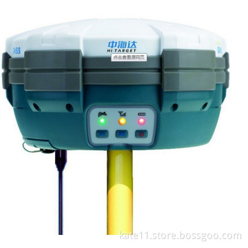
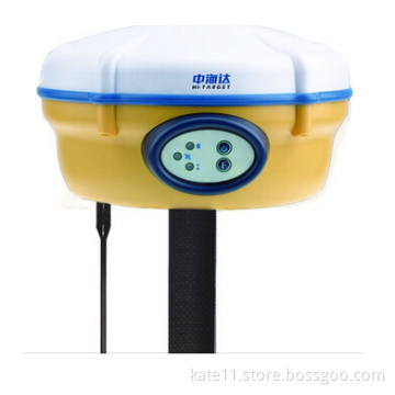
| V60 GNSS RTK SYSTEM | ||||||||||||
| The V60 is a more compact-design and higher-performance GNSS RTK SYSTEM,besides its rugged design to resist impact and vibration. | RINEX Storage | Multi Constellation tracking | ||||||||||
| The static data can be saved directly in RINEX format.The V60 is fully compatible with other brands' receivers. | 220 channels. The V60 is fully compatible with GNSS constellations to track GLONASS,GALILEO,BDS,SBAS as well as GPS. | |||||||||||
| The V60 has industrial OLED display screen on its front control panel to show all information and status of the work. With the smart speak inside the receiver,the DIY guiding voice can be customized in any language,even dialect! | ||||||||||||
| Quik Upgrade | Seamlessly operation in CORS System | |||||||||||
| Just copy the updated firmware to the V60,then restart to finish the upgrade in a few seconds. | With internal 3G modem,the V60 works perfectly with corrections from CORS networks in any version of CMR,RTCM without needing to interpret the message but reading seamlessly. | |||||||||||
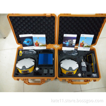
| 1GB internal storage plus 8GB Micro SD card memory is standard,the V60 supports up to 32GB extension of the memory. | Fully Automated Operation | |||||||||||
| Long-life Battery | ||||||||||||
| The V60 is equipped with a smart speaker,which guides the user during operation. The guiding voice can be simply made in any language,even dialect! All its functionalities are designed to make survey jobs to be done conveniently,such as auto base setup by buttons,the rover can get fix solution once it is turned on. No need to spend time setting the parameters for every single operation. | Powered by 5000mAh Li-Ion battery. Static working time 13-15 hours. RTK Rover(UHF/GPRS/3G)working time 10-12 hours. RTK Base working time 8-10 hours. | |||||||||||
| The V60 is fully compatible with other GNSS RTK receivers from the world market.The static data can be saved directly in RINEX format. | ||||||||||||
| Rugged Design,IP67 | ||||||||||||
| KEY FEATURES | ||||||||||||
| The special latching technology in the flexible flat cables ensures trouble-free operation under impact or vibration. The V60 withstands 3 meters natural fall onto concrete. | ||||||||||||
| Linux operation system | ||||||||||||
| ARM 9G20 400MHz CPU,embeded linux OS to support faster data transmissions. | ||||||||||||
| PERFORMANCE SPECIFICATIONS | ||||||||||||
| MEASUREMENTS | HARDWARE(Physical) | |||||||||||
| 1.220 channels 2.Advanced pacific crest maxwell 6 custom survey GNSS technology. 3.High precision multiple correlator for GNSS pseudo range. 4.Unfiltered,unsmoothed pseudo range measurements data for low noise,low multipath error,low time domain correlation and high dynamic response. 5.Very low niose GNSS carrier phase measurements with less than 1mm precision in a 1Hz bandwidth. 6.Signal-to-Noise ratios reported in dB-Hz. 7.Proven pacific crest low elevation tracking technology. | Dimensions(W*H)-.18.20CM*9.80CM | |||||||||||
| Weight-1.25kgs without internal battery | ||||||||||||
| Operating temperature-.-45celcius to +65celcius | ||||||||||||
| Storage temperature-.-55celcius to +85celcius | ||||||||||||
| Humidity-.100%,considering | ||||||||||||
| Water/dustproof-.IP67(dustproof,protected from temporary immersion to depth of 1m. | ||||||||||||
| Shock&Vibration-.Designed to survive a 3m nature fall onto concrete. | ||||||||||||
| Electrical | ||||||||||||
| Power 6v to 28v DC external power input | ||||||||||||
| power consumption less than 3.5w (3.5w is ok) | ||||||||||||
| Automatic swithching between internal power&external power rechargable,removable 7.4v,5000mAh Lithium-Ion battery in internal battery compartment. | ||||||||||||
| Satellite signals tracked simultaneously | ||||||||||||
| GPS-.Simultaneous L1C/A,L2C,L2E,L5 | ||||||||||||
| GLONASS-.Simultaneous L1C/A,L1P,L2C/A,L2P | ||||||||||||
| SBASS-.Simultaneous L1C/A,L5 | I/O interface | |||||||||||
| Galileo-.Simultaneous L1BOC,ESA,E5B,E5AltBOC | 1*standard USB 2.0 port | |||||||||||
| BDS/Compass-.B1,B2 | 1*TNC UHF connector | |||||||||||
| QZSS-.L1C/A,L1 SAIF,L2C,L5 | 2*RS232 serial port | |||||||||||
| 2*DC power input(8-pin&5-pin) | ||||||||||||
| POSITIONING PERFORMANCE | 1*Micro SD card port | |||||||||||
| Static and fast static GNSS surveying | ||||||||||||
| Internal UHF radio(Standard) | ||||||||||||
| Horizontal-.2.5MM+0.5PPM RMS | Frequency-.450~470MHz with 116 channels | |||||||||||
| Vertical-.5MM+0.5PPM RMS | Transmitting power-.1w,2w,5w adjustable | |||||||||||
| Transmitting speed-.9.6Kbps,19.2Kbps | ||||||||||||
| Post processing kinematic(PPK/Stop&Go)GNSS surveying | Working Range-.5km typocal,8~10 km,optimal | |||||||||||
| Horizontal-.1CM+1PPM RMS | ||||||||||||
| Vertical-.2.5CM+1PPM RMS | Extetnal UHF radio(Standard) | |||||||||||
| Initialization time-.typically 10 minutes for base whille 5 minutes for rover | Frequency-.450~470MHz with 116 channels | |||||||||||
| Initialization reliability-.typically more than 99.9% | Transmitting power-.5w,10w,20w,30w adjustable | |||||||||||
| Transmitting speed-.up to 19.2Kbps | ||||||||||||
| Code differential GNSS positioning | Working Range-.8~10km typocal,15-20km optimal | |||||||||||
| Horizontal-.25CM+1PPM RMS | ||||||||||||
| Vertical-.50CM+1PPM RMS | ||||||||||||
| SBAS-.0.50M Horizontal,0.85M Vertical | ||||||||||||
Related Keywords
Related Keywords
You May Also Like
You May Also Like