Portable universal control bluetooth satellite receiver surveying equipment
- Payment Type:
- T/T, L/C, Western Union
- Incoterm:
- FOB
- Min. Order:
- 1 Set/Sets
- Min. Order:
- 1 Set/Sets
- Delivery Time:
- 10 Days
- Transportation:
- Ocean, Air
Quantity:
Your message must be between 20 to 2000 characters
Contact NowBasic Info
Basic Info
| Place of Origin: | China |
|---|---|
| Productivity: | 1000 sets per month |
| Supply Ability: | 1000 sets |
| Payment Type: | T/T,L/C,Western Union |
| Incoterm: | FOB |
| Certificate: | CE,ISO9001 |
| Transportation: | Ocean,Air |
Product Description
Product Description
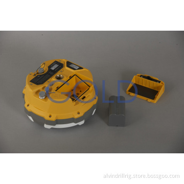
Satellite receive, surveying equipment
High accuracy! Compacted ! Light weight !
Best choice for you !
Application&Features
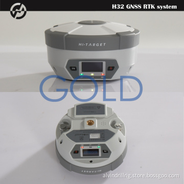
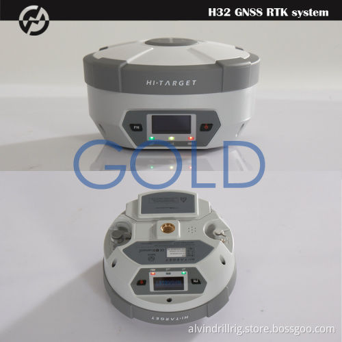
Originated
from HI-TARGET`s sophisticated GNSS technology, the H32 is a very
competitive GNSS RTK system on the current market with its rugged design
and affordable price.
The
H32`s housing is made of General Electric Xenoy 5220U polymer resin to
handle severe and harsh filed conditions. With its unique internal
design, it can perfectly avoid or lessen obstruction and multipath
effect to ensure superior positioning capability.
The H32`s front control panel with super bright OLED display screen (Resolution 128x64) makes the work more intuitive. No matter it is in the dark or strong sunshine, the screen is comfortably readable to eyes.
KEY FEATURES
Multi Constellation Tracking
120 channels. The H32 is fully compatible with GNSS constellations to track GLONASS, GALILEO, SBAS as well as GPS.
All-in-one Transceiver UHF Radio
The
transceiver UHF radio enables the H32`s working mode to be switchable
between base and rover in the same receiver. The H32 provides excellent
performance in UHF RTK operation with its built-in transceiver UHF
radio, which has adjustable transmitting power from o.1 Watt to 2
Watts.
Seamlessly Operation in CORS System
With
internal GPRS modem, the H32 works perfectly with corrections from CORS
networks in any version of CMR, RTCM without needing to interpret the
message but reading seamlessly.
Powerful Battery
Powered by 4400mAh Li-Ion battery.
Static working time 13 - 15 hours
RTK Rover (UHF/GPRS) working time 10 - 12 hours
RTK Base working time 8 - 10 hours
Rugged design, IP67
The
special latching technology on flexible flat cables ensures
trouble-free operation under impact or vibration. The H32 withstands 2
meters natural fall onto concrete.
Field Controller and Software
There
are optional field controllers and software in the H32 package. The
controllers with OS Microsoft Windows Mobile 6.5 are fully compatible
with the third party software such as Carlson SurvCE, MicroSurvey
FieldGenius, Digiterra Explorer, Esri ArcPad etc. besides standard
field&GIS software made by HI-TARGET. HI-TARGET controller with
WiFi, Bluetooth, and GPRS/3G is completely wireless to connect to any
device, collect data and connect to server simultaneously and
seamlessly.
Post-processing Software
HI-TARGET Geomatics Office (HGO) software provides total GNSS solution with a complete suite of programs to support HI-TARGET GNSS receivers. Standard Rinex data and HI-TARGET raw data can be processed flexibly and easily.
Specification
MEASUREMENTS
• 120 Channels
• Proven NovAtel GNSS technology
• Multipath mitigating technology
• Auxiliary strobe signals, including a configurable output for time synchronization and mark inputs
Satellite signals tracked simultaneously
GPS: L1, L2, L2C
GLONASS: L1, L2
Galileo: E1
GIOVE-A/GIOVE-B (test)
BDS/Compass
SBAS
QZSS
POSITIONING PERFORMANCE[i]
Static and Fast Static GNSS surveying
Horizontal: 2.5mm+0.5ppm RMS
Vertical: 5mm+0.5ppm RMS
Post Processing Kinematic
(PPK / Stop & Go) GNSS surveying
Horizontal: 1cm+1ppm RMS
Vertical: 2.5cm+1ppm RMS
Initialization time: typically 10 minutes for base while 5 minutes for rover
Initialization reliability: typically > 99.9%
Real-time Kinematic (RTK) surveying
Horizontal: 10mm+1ppm RMS
Vertical: 20mm+1ppm RMS
Initialization time: typically < 10 seconds
Initialization reliability: typically > 99.9%
Code Differential GNSS positioning
Horizontal: 25cm+1ppm RMS
Vertical: 50cm+1ppm RMS
SBAS: 0.60m Horizontal
HARDWARE
Physical
Dimensions (w x H): 16.5 cm x 10.5 cm (6.50 in x 4.13 in)
Weight: 1.75kg (3.86lb) with internal battery, internal radio, standard UHF antenna
Operating temperature: -45℃to +65℃ (-49℉ to +149℉)
Storage temperature: -55℃ to +85℃ (-67℉ to +185℉)
Humidity: 100%, considering
Water/dustproof: IP67 dustproof, protected from temporary immersion to depth of 1m (3.28ft).
Shock and Vibration: Designed to survive a 2m (6.56ft) natural fall onto concrete.
Display: 128×64 resolution, 1.54 inch OLED screen
Electrical
Power 6V to 28V DC external power input
Power consumption 2.5W
Automatic Switching between internal power and external power
Rechargeable, removable 7.4V, 4400mAh Lithium-Ion battery in internal battery compartment
Internal battery life
Static 13 - 15 hours
RTK Rover (UHF/GPRS) 10 - 12 hours
RTK Base 8 - 10 hours
I/O interface
1 x Bluetooth
1 x standard USB2.0 port
2 x RS232 serial port
2 x DC power input (8-pin & 5-pin)
COMMUNICATION AND DATA STORAGE
GPRS/GSM
Fully integrated, fully sealed internal GPRS/GSM
Network RTK (via CORS) range 20-50km
HI-TARGET internal UHF radio (standard)
Frequency: 460 MHz with 116 channels
Transmitting Power: 0.1W, 1W, 2W adjustable
Transmitting Speed: Up to 19.2Kbps
Working range: 3~5Km typical, 8~10km optimal
HI-TARGET External UHF radio (standard)
Frequency: 460 MHz with 116 channels
Transmitting Power: 5W, 10W, 20W, 30W adjustable
Transmitting Speed: Up to 19.2Kbps
Working Range: 8~10Km typical, 15~20km optimal
Support other external communication device
For example, external GSM modem.
Data storage
64MB internal memory
Data formats
(1Hz positioning output, up to 50 Hz - depends on installed option)
CMR: CMR+, CMR input and output
RTCM: RTCM 2.1, 2.3, 3.0, 3.1 input and output
RTCA: RTCA
Navigationoutputs: NMEA-0183, NovAtel ASCII and Binary logs


Related Keywords
Related Keywords
You May Also Like
You May Also Like